Buying a Home in West Ashley, SC: Where Charleston Began, the Ashley River Road Estates, Long Savanna and the Homework on an Address
On April 11, 2026, re-enactors pitched camp inside the reconstructed palisade at Charles Towne Landing, on the west bank of the Ashley River, to mark 356 years since the colony started on that ground (Live 5 News, April 10, 2026). About 200 settlers had come ashore at Albemarle Point in April 1670 and started earth-and-wood fortifications almost at once. Within two years they laid out a new town on Oyster Point, across the river, and by the spring of 1680 the colony had moved there for good (Charleston County Public Library, Charleston Time Machine; SC State Parks). So the peninsula most of us picture when we say Charleston came second, and the colony's first ten years were spent on this side of the river.
West Ashley is the part of Charleston west of the Ashley River, most of it inside the City of Charleston's limits, laid out along Savannah Highway, Sam Rittenberg Boulevard, Ashley River Road, Bees Ferry Road and Glenn McConnell Parkway. I'm Jeff Moran, NMLS #483943, a mortgage broker licensed in South Carolina through C2 Financial Corporation, and I have been in the mortgage business since 1996. I work out of Bluffton, and I wrote this page for a client weighing a home west of the Ashley. I have laid it out the way the place is laid out, road by road, from the river out to the newest neighborhoods, and then the homework. Here that means the drainage basins, who sends the tax bill, the county line on Highway 61 and the sewer agreement signed this year, all written as things to check before you compare two addresses. Everything here comes from a public source, cited beside the fact, and was checked on October 2, 2026. The three-county picture, the loan limits and the harbor's flood record are on the Charleston area page.
The river, the bridges and the name
"West of the Ashley" is the formal name, and West Ashley is what everyone says, because the whole place is defined by being on the far side of that river from downtown (Wikipedia, West Ashley). You will cross it most days on the Ashley River Memorial Bridge, which carries US 17. It opened in January 1926, dedicated to the South Carolinians who served in World War I, and it turned 100 this past January. It is a drawbridge of the kind called a bascule, which means the roadway itself tilts up to let boats through, and a companion span joined it in 1961 (Post and Courier, 2026; SC Picture Project, Ashley River Bridges). Savannah Highway, which is US 17 once you are across, began as a privately owned turnpike with a toll bridge. In 1921 both ended and it became a public highway, and shops and restaurants then followed along its first nine miles (Charleston County Public Library, Savannah Highway).
A second crossing, for bikes and walkers, is under construction. The Ashley River Crossing broke ground in January 2025 (Live 5 News, January 8, 2025). By February 2026 crews had put in more than 1,600 linear feet on the West Ashley approach. On February 10 City Council approved another $437,500, part of it to finish the eastern landing with a direct link into the Medical District and part for cleanup after crews hit an unexpected creosote pile. It is on schedule to open in mid-2027, and it will be the first cable-stayed movable swing bridge in the United States (City of Charleston, Ashley River Crossing; Walsh; Post and Courier, February 2026). If you work at MUSC or Roper downtown, that is a ride to work that skips the Memorial Bridge.
Ashley River Road: the St. Andrews name, the old church and three estates
Ashley River Road is Highway 61, and it has been a road since 1691. It is both a State Scenic Byway and a National Scenic Byway, with the scenic stretch running about ten miles north from the Church Creek bridge (Wikipedia, SC Highway 61). You will see the name St. Andrews on your tax bill if the home is in one of the unincorporated pockets, and again on St. Andrews Boulevard and the old high school. That is because St. Andrew's Parish was the name for this whole side of the river. The parish was created in 1706 to serve the planters along the Ashley, and it ran as its own unit of local government until 1865 (Wikipedia, Old St. Andrew's Parish Church; Discover South Carolina). The church that gave it the name is still there. Old St. Andrew's Parish Church, at 2604 Ashley River Road, was built in 1706, and it is the only colonial church in South Carolina built in the shape of a cross. Wikipedia's summary calls it the oldest surviving church building south of Virginia (Wikipedia, Old St. Andrew's Parish Church; Discover South Carolina).
Three estates line the road upriver, and all three are open to the public. Drayton Hall, at 3380 Ashley River Road, was begun in 1738. The National Trust has kept it since 1974 exactly as it received it, which means no plumbing and no central air or heat (National Trust for Historic Preservation; American Battlefield Trust). Magnolia Plantation and Gardens, at 3550, was started in 1676 by the Drayton family, which still owns it, and it calls itself the oldest public garden in the United States (Clio; Wikipedia, Magnolia Plantation and Gardens). Middleton Place, at 4300, dates from about 1738, and its grounds are a National Historic Landmark (Library of Congress, HABS sc0241; Historical Marker Database). These were working plantations, and the labor on them was enslaved. Middleton Place carries a Charleston 29414 mailing address but is in Dorchester County, and I come back to that in the homework below.
Life on the road this year: Mazal, Israeli-rooted Mediterranean street food, opened at 1901 Ashley River Road in July 2026 (West Of; Mazal). In January 2026 the St. Andrews Public Service District opened Fire Station 3 at Old Parsonage Road and Ashley River Road, shared with Charleston County EMS, with three bays, two engines and a full-time EMS squad. If your home is in the district rather than the city, that is the station that answers. The rest of that land is a passive park with a retention pond built for the Church Creek basin (Live 5 News, January 14, 2026).
Savannah Highway: the first suburbs, Avondale and the mall
Once the 1926 bridge was open and Charlestonians had cars, developers turned the fields on this side into subdivisions, which is why the streets closest to the river are the oldest ones. The Crescent and Windermere came in 1926, Stono Park in 1928 and Byrnes Downs in 1943. The Harrison, Ravenel and Simons families sold the land that became Wappoo Heights, Avondale, Moreland, Ashley Forest and South Windermere as well (CHS MLS, The History of West Ashley). Byrnes Downs, named for James F. Byrnes, Secretary of State under President Truman, has 347 single-family homes on curving streets with yards and driveways, which were new to city residents at the time. The city has written an Area Character Appraisal for it, and another for Old Windermere (City of Charleston, Byrnes Downs Area Character Appraisal; City of Charleston, Old Windermere Area Character Appraisal). If you are looking at a home in either one, those two documents are the best short read on why the street looks the way it does.
Avondale is the small business district off Savannah Highway, with restaurants, murals and shops, and the owners there started calling it Avondale in 2004 to bring the strip back (6AM City, CHStoday; West Of). Nirlep, the Indian restaurant at 908 Savannah Highway, closed at the end of 2023, was torn down and rebuilt with two clay ovens and a bar, and reopened on September 15, 2026 (Post and Courier, September 2026).
Citadel Mall opened on July 29, 1981 where Savannah Highway meets Sam Rittenberg Boulevard, with Sears, Belk and Thalhimer's as its anchors (Live 5 News, This Day in History; Wikipedia, Citadel Mall). It is turning into a medical campus, and if you live nearby you will watch that happen over the next few years. MUSC Health has run its West Ashley Medical Pavilion inside the mall since December 2019. In December 2025 it bought a large part of the property for $83.5 million (Post and Courier; Live 5 News, December 18, 2025). The planned MUSC West Campus is to hold an ambulatory surgery center, imaging, ENT, a lab, physical therapy, primary care and a spine center (ABC News 4). Belk, Dillard's and Target stay, and in March 2026 three smaller tenants, the model railroad club and the planetarium among them, were given until May 31 to move out (Live 5 News, March 16, 2026). Part of the site was approved years ago for buildings up to 18 stories, so the skyline near the mall could change (Post and Courier, December 2019).
Sam Rittenberg Boulevard: Ashley Landing and the plan for a main street
The road everyone calls Sam Rittenberg was Highway 7 until 1972, when the stretch between US 17 and the North Bridge was renamed. Samuel Oscar Rittenberg was a state legislator who co-wrote the bill that created the Charleston County Library (College of Charleston, Mapping Jewish Charleston). If you buy on this side of West Ashley, the boulevard is the commercial strip you will use most, and the city's long plan for it is called Plan West Ashley. The public process started in spring 2017, and City Council adopted it unanimously in February 2018. Dover, Kohl & Partners wrote it with the 19-member West Ashley Revitalization Commission. Its goals cover roads, drainage, bike and walking paths, and the aging commercial strips on Sam Rittenberg and Savannah Highway (City of Charleston, Plan West Ashley; Charleston City Paper, February 14, 2018). The city has since run a Sam Rittenberg Boulevard Redesign project (City of Charleston), and the Post and Courier described the goal in 2018 as "West Ashley's version of King Street" (Post and Courier).
Ashley Landing is the first big piece of that. It is a 35.5-acre redevelopment on Sam Rittenberg, bordered by Old Towne Road, that broke ground in May 2025 with full completion expected in 2028. The plan includes a new Publix of just over 50,000 square feet, a city park, nine acres of stormwater retention and affordable units (Live 5 News, January 8, 2026). The Post and Courier puts the project at $348 million. It reports that the new Publix must be delivered by October 31, 2026, and that it will be about 2,000 square feet bigger than the 48,391-square-foot store, which stays open until the move (Post and Courier). I could not confirm whether the new store has opened yet.
Bees Ferry Road and Glenn McConnell Parkway: the ferry, the newer neighborhoods and Long Savanna
Bees Ferry Road is named for a real ferry. The legislature created it in December 1703 over a narrow bend of the Ashley, about two miles upstream of where the I-526 bridge crosses today. The same act laid out the road to it, as the public route from Charleston to the town of Wilton on the Edisto. In December 1821 the ferry was granted to Joseph F. Bee, and by around 1860 it was known as Bee's Ferry. The ferry is gone, and a railroad bridge now crosses the river near the old landing. So when you drive Bees Ferry Road to look at a home, you are on a route that has been public since 1703 (Charleston County Public Library, What (and Where) is Bee's Ferry?; Tidelines, September 7, 2020).
Most of the neighborhoods out here followed the highways. The largest growth west of the Ashley came in the 1970s and 1980s. I-526 was built in the early 1980s and Glenn McConnell Parkway, which is SC 461, in the 1990s, with a wave of building after each one (Wikipedia, West Ashley). Grand Oaks Plantation, with about 1,400 homes, went up in the late 1990s. Hunt Club, with about 500 homes, followed in the early 2000s, and Carolina Bay, off Glenn McConnell Parkway, has about 1,800 homes (Post and Courier, March 2025). Bees Ferry Road itself was widened from two lanes to four for most of the 4.5 miles between Highway 61 and Highway 17, after almost three years of construction (Live 5 News).
The largest project still to come is Long Savanna. It is planned at 4,500 homes on about 3,300 acres around Bear Swamp Road, off Bees Ferry and Savannah Highway, with a city park, a county park and ten neighborhoods of homes. It has been in the works for nearly twenty years (Post and Courier, 2018). On September 24, 2026 it moved another step closer to construction, as the city and the developer worked out changes meant to ease the effect of that many new homes (Live 5 News, September 24, 2026). The Post and Courier counted about 6,000 housing units in the works within a five-mile drive along Bees Ferry, Glenn McConnell and Henry Tecklenburg Drive, Long Savanna among them (Post and Courier, March 2025). Not everything proposed out here gets built, either. Charleston County turned down a rezoning for about 100 townhomes on Bees Ferry Road, and the city set aside 14 acres on the road for conservation (Post and Courier; Post and Courier).
Glenn McConnell Parkway is being widened as well, and this one is a county project. It takes about two miles of it from four lanes to six between Bees Ferry Road and Magwood Drive. It adds a 10-foot bike and walking path, a new signal at Essex Farms Drive, upgrades at three intersections and seven bus stops with shelters, paid for by the county's 2016 transportation sales tax (ABC News 4; Charleston County Roads). I could not confirm where that work stands this fall, so if you are looking in Carolina Bay or Grand Oaks, please drive it at the hour you would commute. "Glenn McConnell at Magwood" is also on the county's November 3, 2026 transportation sales tax list (Live 5 News, April 23, 2026). At the outer edge, where US 17 meets Main Road, the $354 million interchange shared with Johns Island is under construction. The roundabout and one ramp are targeted for the end of 2026, and the whole project for the end of 2028 (Live 5 News, April 21, 2026). On I-526, only the Paul Cantrell Boulevard end of the state's Lowcountry Corridor WEST project touches West Ashley, and mainline widening there is not scheduled to begin until about 2029 (I-526 Lowcountry Corridor).
The hospital for this side of the river is on this corridor. Bon Secours St. Francis Hospital, at 2095 Henry Tecklenburg Drive, moved from the peninsula to West Ashley in 1996. It has 204 beds, and its operator describes it as the only 24-hour emergency room in West Ashley. Its roots go back to 1882, when five Sisters of Charity of Our Lady of Mercy opened St. Francis Infirmary downtown (Roper St. Francis, Bon Secours St. Francis Hospital; Roper St. Francis, Our History). Roper St. Francis also opened an Express Care at 3885 West Ashley Circle, off Bees Ferry, in April 2021 (Roper St. Francis). I did not find a freestanding emergency room in outer West Ashley, so for a home out past Bees Ferry, Henry Tecklenburg Drive is the ER.
Schools: District 10, the sixth-grade academy and the November ballot
West Ashley's schools are in the Charleston County School District. The district divides the county into smaller areas it calls constituent districts, and West Ashley's is District 10, which is the name you will hear at a board meeting or in a news story about local schools (ABC News 4). West Ashley High was created in August 2000, when the district merged Middleton High and St. Andrews High. The new building was late, so the school opened on two campuses (Wikipedia, West Ashley High School; West Ashley High School). The district is replacing the sixth-grade campus at C.E. Williams North, on William Kennerty Drive, with a $46 million building paid for by the one-penny sales tax, with classrooms for 600 students and a cafeteria and gym sized for 900. The old Middleton High building, which has served as the sixth-grade campus, is to be demolished for athletic fields. Completion was expected in 2026 (Post and Courier, Education Lab, May 2024). I could not confirm whether it opened for this school year, so please ask the district.
On November 3, 2026, Charleston County voters decide whether to extend the district's 1% education sales tax through 2034. The West Ashley items on that list are a new elementary school in Long Savanna, planned for up to 1,200 students and paired with an early-education center, and new buildings on the former St. Andrews High campus. Those buildings are for Orange Grove Middle Charter and Pattison's Academy (ABC News 4, July 20, 2026; Post and Courier, 2026). It is a sales tax, so it would not add a line to a property tax bill, and nothing on that list is funded until the vote passes. The district's current attendance map is the place to confirm the schools for any address.
The Greenway, the farmers market and the parks on the river
The West Ashley Greenway, which everyone just calls the Greenway, runs on the old Croghan's Branch of the Atlantic Coast Line Railroad. Seaboard Coast Line gave up the line in 1981, and Charleston Water System bought the corridor in 1984 and 1985 as a utility right of way. The city opened the first unpaved stretch in late 1989 and finished the last section in 2007. Wikipedia puts it at 8.8 miles, from Main Road in the west to Folly Road in the east, and other sites say about ten (Wikipedia, West Ashley Greenway; City of Charleston, West Ashley Greenway Plan; SC Trails). If a home you are looking at backs up to it, please note that the stretch between Campbell Drive and Wesley Drive is closed in 2026 for the Windermere drainage work I describe below.
The West Ashley Farmers Market sets up at Ackerman Park, 55 Sycamore Avenue. In 2026 it ran Wednesdays from 3 to 7 p.m., April 1 through October 14, its earliest opening ever, with a Thanksgiving Market on Sunday, November 22 from noon to 4 (City of Charleston; Holy City Sinner).
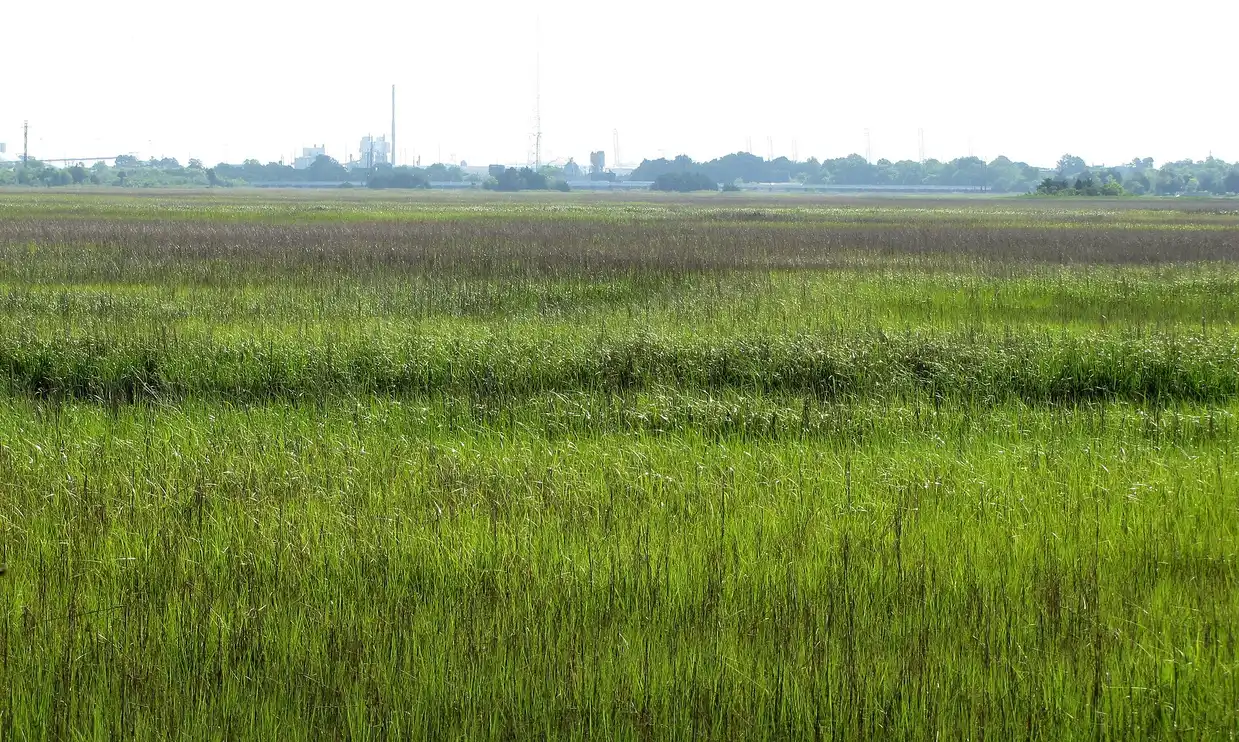
Charles Towne Landing itself is a 664-acre state historic site at 1500 Old Towne Road, and the marsh in the photo at the top of this page is there (SC State Parks). It has a replica 17th-century ship, the Animal Forest zoo, an avenue of live oaks, six miles of trails and the Legare Waring House. Next door, Old Towne Creek County Park at 1400 Old Towne Road has trails, boardwalks and an arboretum on land a mother and daughter donated, with trail signs that tell the history of West Ashley (Charleston County Parks). Pierpoint Boat Landing at 94 Cedar Lane is a paddle-only launch on Church Creek (Charleston County Parks). Lenevar Park has an off-leash dog area and four tennis courts, West Ashley Park at 3601 Mary Ader Avenue has fields and trails, and Carr Richardson Park is on the Ashley in the Maryville and Ashleyville area (City of Charleston). The library system has three branches on this side of the river, Bees Ferry West Ashley on Sanders Road, West Ashley on Windermere Boulevard and Hurd/St. Andrews on North Woodmere Drive (Charleston County Public Library).
The homework starts with water: Church Creek, Windermere and the basins
For any address on this side of the river, it is worth looking up which drainage basin it is in. The city plans and pays for its drainage work basin by basin, and you will want to know what is planned for yours. Church Creek is a channel ten feet wide that drains nearly 5,000 acres to the Ashley, and the basin takes in Shadowmoss, Hickory Hill, Hickory Farms, Grand Oaks, Village Green, Forest Lakes and Canterbury Woods (Post and Courier, November 2017). The Bridge Pointe townhomes in the Shadowmoss area, built in the late 1980s, flooded four times in three years after a mapping error left them exposed. The city bought 36 homes for $8 million, 32 of them at Bridge Pointe, and began demolition at 8:30 in the morning on July 10, 2019. The ground is now the six-acre Bridgepointe Ecological Park, built with The Nature Conservancy to hold stormwater and let it out slowly (Post and Courier, July 2019; City of Charleston, Bridgepointe Ecological Park). The city keeps a Buyout Program page and a Church Creek Drainage Basin page that list what is under way (City of Charleston, Buyout Program; City of Charleston, Church Creek Drainage Basin).
Two drainage projects are under way as I write this. The Lake Dotterer Flood Reduction Project, north of Glenn McConnell in the Church Creek basin, is a city, county and Charleston Water System partnership. Part of the money is the county's share of federal pandemic relief funds, the American Rescue Plan Act, which you will see shortened to ARPA in the news coverage. It widens drainage pipes and raises the berm to hold back tidal water and add storage, at an estimated $1 million to $5 million. Thomas & Hutton was hired in November 2024 to design it, with design due by June 2026 and construction to follow (Live 5 News, March 11, 2026; City of Charleston, Lake Dotterer). I could not confirm whether construction has started. On the other side of Highway 17, Windermere is between the Ashley River and Wappoo Creek, and its $12.6 million drainage project, planned in some form since the mid-1980s, started construction in June 2026. Charleston Water System is paying about $2.4 million for utility relocation, the state $4.5 million and the city's stormwater fund $5.7 million. Phase one closed Culbertson Drive by St. Andrew's School of Math and Science and the Greenway between Campbell and Wesley (Live 5 News, June 22, 2026; Post and Courier, Rising Waters, 2026). The new fire station on Ashley River Road added a retention pond for the Church Creek basin as well. South Carolina's seller disclosure asks about flood history and past claims, and the harbor's tidal flood record is on the Charleston area page.
City of Charleston or St. Andrews Public Service District
West Ashley is one place with two local governments, and that is the next thing to check on an address. The City of Charleston first grew beyond the peninsula under Mayor J. Palmer Gaillard Jr., when it began annexing the suburbs west of the Ashley around 1960 (Charleston Magazine; Wikipedia, J. Palmer Gaillard Jr.). It has added West Ashley land piece by piece ever since, and the pockets it has not annexed are unincorporated Charleston County, served by the St. Andrews Public Service District. The district was created by the legislature in 1949, when West Ashley was entirely unincorporated, and it is an independent unit of government, separate from the county and the city. It still provides fire, rescue and first-responder service, trash pickup and street lighting to about 18,600 people in the unincorporated pockets (Post and Courier; St. Andrews PSD). So two homes on the same street can be billed by different governments and served by different fire departments, the city's or the district's.
I could not confirm which named neighborhoods are wholly inside the city, wholly in the district or split, so please have the listing agent pull the Charleston County parcel record, which shows the tax district, before you compare two homes. The difference reaches the millage, the fire department and the flood insurance discount. Millage is the tax rate on the bill, counted in mills, and a mill is $1 of tax for every $1,000 of assessed value. The city and the district each set their own rate. On the discount, a 2021 report gave the City of Charleston a Class 6 rating in FEMA's Community Rating System, which is worth up to a 20% discount on National Flood Insurance Program premiums (Post and Courier, June 2021). A 2023 report gave unincorporated Charleston County a Class 2, worth 40% (Post and Courier, June 2023). Both could have changed since, so please ask your insurance agent for the discount on the specific address. For a home in a Special Flood Hazard Area, the high-risk zone on FEMA's map, the lender requires flood insurance, and the premium is part of your monthly payment.
North Charleston is a third government out on Highway 61. It holds some land along Ashley River Road, including the 113-acre Runnymede Plantation tract it annexed in 2017 (Live 5 News, January 21, 2026). So on a home along Highway 61, please have the Charleston County parcel record confirm which city, if any, bills it.
The county line on Ashley River Road
Middleton Place, at 4300 Ashley River Road, carries a Charleston 29414 mailing address, and the Library of Congress places it in Knightsville, Dorchester County (Library of Congress, HABS sc0241; SC Picture Project). Everything else on this page is in Charleston County, including Drayton Hall and Magnolia, a few miles back toward town. The Ashley River Road historic corridor runs along Highway 61 from Church Creek to SC 165 and reaches into Dorchester County (Coastal Conservation League). I did not find any home or subdivision in Dorchester County that clients call West Ashley. A 29414 ZIP code by itself does not settle the county, though, so on a home out past Drayton Hall, please have the parcel record confirm it before you compare tax figures.
Water and sewer: the 1995 takeover and this year's agreement
Charleston Water System took over the St. Andrews Public Service District's sewer system during 1995 under a state consent decree, which is a binding agreement with the state's environmental agency that spelled out what had to be fixed. The district's system, as the Southern Environmental Law Center put it, had been improperly designed, installed and mismanaged for decades. The utility closed two failed treatment plants and runs an inflow and infiltration program, which is the work of keeping rainwater out of sewer pipes (Southern Environmental Law Center). In 2024 Charleston Waterkeeper, represented by that law center, filed a notice of intent to sue under the Clean Water Act over sanitary sewer overflows in West Ashley. In January 2026 Waterkeeper and Charleston Water System reached an agreement to address them (Live 5 News, February 4, 2026; Charleston City Paper, February 3, 2026). I could not confirm the water and sewer provider for every address, so please ask which utility bills the home. On a new home, please ask the builder about tap or capacity fees, the one-time charges to connect it.
The tax bill: city millage, district millage and the stormwater line
For the 2025 tax year, the City of Charleston levies 82 mills on its Charleston County homes, and the St. Andrews Public Service District levies 73 mills on the unincorporated pockets. Charleston County's base levy is 50.6 mills either way (SC Association of Counties, 2025 Property Tax Rates by County, February 2026 revision). A home you live in as your legal residence is assessed at 4% of its value once the Charleston County Assessor approves your application, which is due by January 15 (Charleston County Assessor). Charleston County also takes a local option sales tax credit off the bill, figured by multiplying the appraised value by a published factor. For 2025 that factor is 0.000820, the same number for a city address and for an unincorporated county address, so the credit comes out the same either way and only the millage changes with the government that bills you.
A city address also carries a stormwater line. The city's stormwater fee was $11 a month on the Charleston Water System bill from 1996. Starting with the 2026 service year, it appears as a single $132 annual charge on the property tax bill instead (City of Charleston, Stormwater Service Billing). A purchase also resets the taxable value, and the South Carolina page explains why the second bill after closing is the one to look at.
Putting these lines into your payment
The lender qualifies you on a monthly payment, and that payment carries the recurring costs above. Here that means the county's mills, the city's or the district's mills, the $132 stormwater line on a city address, flood insurance where it applies and any association dues. I have not published dues for Carolina Bay, Grand Oaks, Shadowmoss, Hunt Club or Long Savanna, because I have not confirmed them against the associations' own resale documents. Please ask the listing agent for the resale package before you settle on a number. The 2026 conforming and FHA loan limits for Charleston County are the same across the metro, and the box below this article shows them.
Pre-approval in South Carolina explains what the letter is based on and what it is worth to a seller. If you already own in Windermere, Byrnes Downs or the Crescent and are weighing whether to stay and refinance, refinancing in South Carolina covers what a refinance does and does not change. If Summerville is also on your list, the Summerville page does the same homework for a town that reaches into three counties. Once you are ready, you can run the numbers for a West Ashley purchase with no credit pull and no account, then choose a rate option. The option you choose can change later if your plans do.
Nothing on this page is a loan approval, a denial or a commitment to lend, and none of it is tax advice. The Charleston County Assessor sets the classification and the value on a specific parcel. The county parcel record shows whether a parcel is inside the City of Charleston or the St. Andrews Public Service District, so please confirm both before you rely on them.
Common questions
Is West Ashley in the City of Charleston?
Most of it is. The city began annexing the suburbs west of the Ashley River around 1960, and it has taken in West Ashley piece by piece since. The pockets it never annexed are unincorporated Charleston County, served by the St. Andrews Public Service District, which was created in 1949 and runs its own fire department. The Charleston County parcel record shows which one a given home is in.
Which county is West Ashley in?
Charleston County. Its tax bill, its 4% legal-residence application and its schools, in the Charleston County School District, all come through Charleston County. Middleton Place, out on Ashley River Road, has a Charleston mailing address and is in Dorchester County, so on a home that far out, the parcel record is the way to confirm the county.
What is being built off Bees Ferry Road?
Long Savanna, planned at 4,500 homes on about 3,300 acres around Bear Swamp Road, with a city park, a county park and ten neighborhoods. On September 24, 2026 another piece of it moved closer to construction. The Post and Courier counted about 6,000 housing units in the works within a five-mile drive along Bees Ferry, Glenn McConnell Parkway and Henry Tecklenburg Drive. The November 3, 2026 school sales tax referendum includes a new elementary school inside Long Savanna.
What is happening to Citadel Mall?
MUSC bought a large part of it in December 2025 and plans an MUSC West Campus there, with an ambulatory surgery center, imaging, ENT, a lab, physical therapy, primary care and a spine center. MUSC Health's West Ashley Medical Pavilion has operated inside the mall since December 2019. Belk, Dillard's and Target stay, and three smaller tenants were given until May 31, 2026 to move out.
Is there a hospital in West Ashley?
Yes. Bon Secours St. Francis Hospital, at 2095 Henry Tecklenburg Drive, moved to West Ashley from the peninsula in 1996 and has 204 beds, with what its operator describes as the only 24-hour emergency room in West Ashley. Roper St. Francis runs an Express Care on West Ashley Circle off Bees Ferry Road, and MUSC has its medical pavilion at Citadel Mall.
Does a home in West Ashley need flood insurance?
If it is in a Special Flood Hazard Area, the high-risk zone on FEMA's map, the lender requires it, and the premium becomes part of the monthly payment. Outside that zone it is your choice. Either way, please ask which drainage basin the home is in and read the seller's disclosure on flood history. Your insurance agent can tell you what discount the City of Charleston or unincorporated Charleston County earns on that address under FEMA's Community Rating System.
2026 loan limits, one-unit home
| County | FHA | Conforming |
|---|---|---|
| Charleston County | $690,000 | $832,750 |
Source: HUD Mortgagee Letter 2025-23; FHFA, Nov 25 2025. HUD · FHFA
Places to go in West Ashley
Showing 12 of 12
Parks
Park · West Ashley
Carr Richardson Park
This Ashley River park in the Maryville/Ashleyville area includes a small indoor building with restrooms and a catering kitchen.
Outdoors
- ADA accessible
- pavilion
- Playground
- walking track
- picnic areas
- water feature
1071 Bender St, Charleston, SC 29407
Official site · Checked
Park · West Ashley
Old Towne Creek County Park
The property was donated by a mother and daughter, and signs along the trails explain the history of West Ashley.
Outdoors
- trails
- boardwalks
- arboretum
- nature-themed playground
- interpretive signage
1400 Old Towne Rd, Charleston, SC 29407
Official site · Checked
Park · West Ashley
West Ashley Park
Swimming, diving and jumping off the docks or piers are not allowed here.
Outdoors
- athletic fields
- basketball court
- pavilion
- picnic areas
- Playground
- trails
3601 Mary Ader Avenue, Charleston, SC 29414
Official site · Checked
Boat ramps
Boat ramp · West Ashley
Pierpoint Boat Landing
This Church Creek landing is meant for kayaks and canoes; CCPRC does not recommend launching standard-size boats here.
Outdoors
- paddle launch
94 Cedar Ln, Charleston, SC 29414
Official site · Checked
Dog parks
Dog park · West Ashley
Lenevar Park
A walking trail circles the park, and there is a separate off-leash dog area.
Outdoors
- off-leash dog area
- four tennis courts
- two playgrounds
- ball field
- half basketball courts
- perimeter walking trail
1309 South Lenevar Drive, Charleston, SC 29407
Official site · Checked
Libraries
Library · West Ashley
Bees Ferry West Ashley Library
This Charleston County Public Library branch lists its meeting rooms, programs and calendar through ccpl.org.
Indoors
3035 Sanders Rd., Charleston, SC 29414
Official site · Checked
Library · West Ashley
Hurd/St. Andrews Library
This Charleston County Public Library branch lists its meeting rooms, programs and calendar through ccpl.org.
Indoors
1735 N. Woodmere Drive, Charleston, SC 29407
Official site · Checked
Library · West Ashley
West Ashley Library
This Charleston County Public Library branch lists its meeting rooms, programs and calendar through ccpl.org.
Indoors
45 Windermere Blvd., Charleston, SC 29407
Official site · Checked
Pools
Pool · West Ashley
W.L. Stephens Aquatic Center
The city posts current swim hours, classes and swim team details on its aquatics page rather than the facility page.
Outdoors
- pool
- Parking
- Playground
- Restrooms
780 West Oak Forest Dr, Charleston, SC 29407
Official site · Checked
Museums
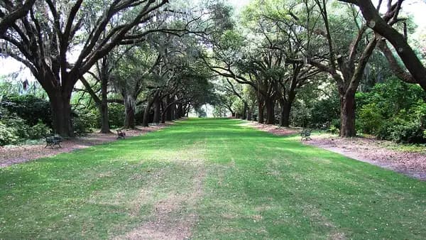
Photo: Brian Stansberry, CC BY 3.0, via Wikimedia Commons. Museum · West Ashley
Charles Towne Landing State Historic Site
This is the 1670 site of the first permanent English settlement in South Carolina; leashed pets are welcome in most outdoor areas but not in the Animal Forest.
Outdoors · Fee
- replica 17th-century ship
- Animal Forest natural-habitat zoo
- gardens and oak alley
- 6 miles of walking and biking trails
- visitor center exhibits
- EV charging
1500 Old Towne Road, Charleston, SC 29407
Official site · Checked
Courts
Courts · West Ashley
Bees Landing Recreation Center
The recreation center pairs indoor programs such as senior activities and youth fitness with outdoor fields and a dog park.
Outdoors
- athletic and baseball fields
- basketball court
- dog park
- football field
- Playground
- Restrooms
- tennis
1580 Ashley Gardens Blvd., Charleston, SC 29414
Official site · Checked
Courts · West Ashley
Peggy Bohne Tennis Center
The center runs lessons, novice tournaments and an inner-city youth tennis program.
Outdoors
- tennis
- locker room
- Restrooms
19 Farmfield Avenue, Charleston, SC 29407
Official site · Checked
Nothing on this list matches every filter you picked. Clear one to see more.
Parks, beaches and places to go around Charleston →
Local facts on this page checked October 2, 2026.
See what your numbers actually support.
Live rates for your scenario, the whole sheet side by side, and every closing fee — before we talk.
Jeff Moran, NMLS #483943, licensed to originate in South Carolina through C2 Financial Corporation.