Buying a Home on James Island, SC: Fort Johnson, Folly Road, Sol Legare, the Muni and the Three Governments on One Island
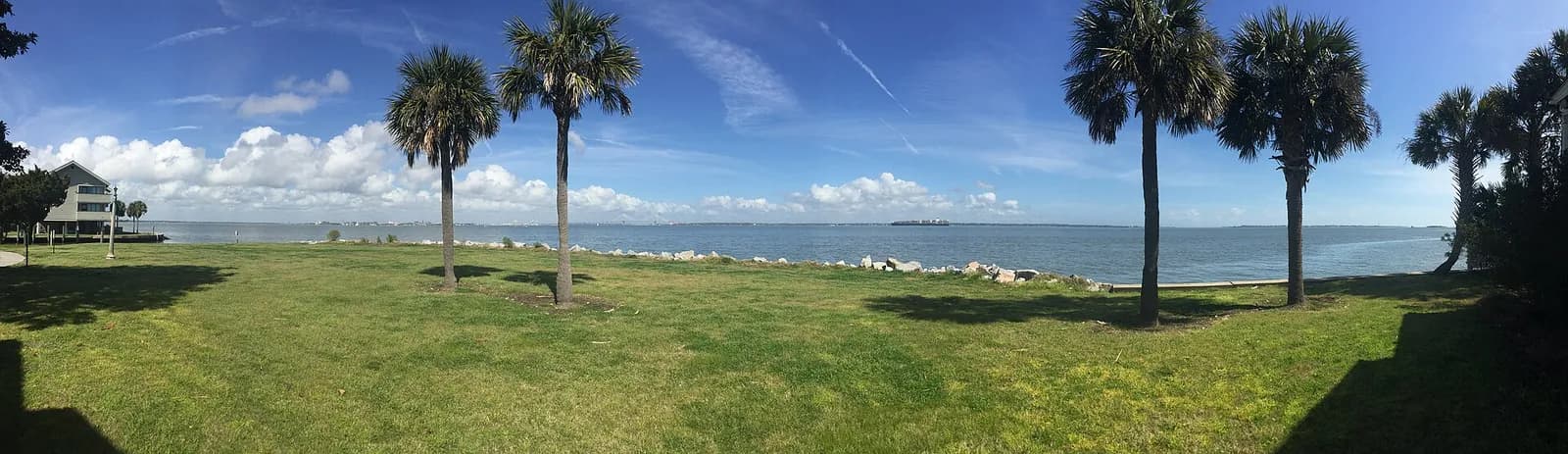
At 4:30 in the morning on April 12, 1861, a single 10-inch mortar round left Fort Johnson, on the northeast point of James Island, and burst over Fort Sumter. Henry S. Farley fired it on the order of Capt. George S. James. It was the signal, and 43 Confederate guns and mortars opened up on the fort across the harbor (Historical Marker Database, The First Shot of the War of Secession; American Battlefield Trust, Fort Johnson). The lawn in the photo at the top of this page is that same point of land. Today it holds the College of Charleston's Grice Marine Laboratory, the state's Marine Resources Research Institute and the Hollings Marine Laboratory. NOAA, NIST and MUSC scientists share that campus with the state's marine biologists (College of Charleston, Grice Marine Lab; NOAA, Hollings Marine Laboratory).
I'm Jeff Moran, NMLS #483943, a mortgage broker licensed in South Carolina through C2 Financial Corporation, and I have been in the mortgage business since 1996. I work out of Bluffton, and I wrote this page for a client weighing a home on James Island. James Island is a sea island framed by the Ashley River, Charleston Harbor and the Stono River, joined to downtown Charleston by the James Island Connector and to West Ashley by the Wappoo Cut bridge. Folly Road runs down the middle of it from the Wappoo Cut to Folly Beach (Wikipedia, James Island; SCIWAY, James Island). I work around the island the way you would drive it, and then I get to the homework on any address here, starting with a town that took four tries to incorporate. Everything here comes from a public source, cited beside the fact, and was checked on October 3, 2026. The three-county picture, the loan limits and the harbor's flood record are on the Charleston area page.
The harbor point: Fort Johnson, Secessionville and the roads out to them
Fort Johnson is older than the shot it is famous for. The first fort went up there in 1708, built of tabby, a concrete of oyster shell and lime, and pieces of that tabby are still visible on the point. The brick powder magazine from 1765 still stands, and in September 1775 Col. William Moultrie's men raised the South Carolina liberty flag over the fort for the first time (SC Encyclopedia, Fort Johnson; American Battlefield Trust, History of Fort Johnson). Fort Johnson Road runs out to that point today, so the ground at the end of your drive is the same ground the marine labs at the top of this page stand on.
The island's other battlefield is a few miles south. On June 16, 1862, Union troops made a frontal assault on an earthwork at Secessionville, across a neck of land about 125 yards wide. The defenders held, the work was renamed Fort Lamar, and the ground is now the Fort Lamar Heritage Preserve (National Park Service, Battle of Secessionville; American Battlefield Trust, Fort Lamar). The Town's free Voices of the Revolution driving tour, launched in November 2024 with a $12,000 grant from the SC250 Commission, has eight stops with audio narration by Charleston guide Evans Byrd. They include the former site of Fort Johnson, the Stiles-Hinson House and the site of the Battle of Dills Bluff (Live 5 News, November 1, 2024). The Stiles-Hinson House is two homes built back to back, the first in 1742 by Benjamin Stiles, and the Stiles Point Plantation neighborhood takes its name from it (Town of James Island, Historic Sites).
The neighborhoods out this way carry that history in their names. Stiles Point Plantation, between Harbor View and Fort Johnson roads, is about 200 homes, most of them custom built from the 1970s through the 1990s. Lawton Bluff, off Harbor View Road, is about 600 homes from the 1960s, mostly brick ranches, some on James Island Creek. Fort Johnson Estates is at the end of Fort Johnson Road, with homes from the 1950s through the late 1980s (Search for Charleston Real Estate, Stiles Point Plantation; NV Realty Group, Fort Johnson Estates). A home in any of these is decades old, so I would give the inspection and the insurance quote a little extra time. Fort Johnson Road itself is under construction, and if your commute runs down it, you will be driving through that work into 2027. Its intersection with Camp Road became a compact roundabout that opened in August 2026. Its intersection with Secessionville Road is getting a signal, crosswalks and turn lanes, with the signal expected from October 2026 (Live 5 News, September 29, 2026). Melton Peter Demetre Park at 640 Wampler Drive is the only City-owned waterfront park on the island, with a view across the harbor to the Battery and the Ravenel Bridge. The City's Bayview Soccer Complex is at 1045 Fort Johnson Road (City of Charleston, Melton Peter Demetre Park; City of Charleston, Bayview Soccer Complex).
Sol Legare: the causeway, the Lodge and Mosquito Beach
Sol Legare is a smaller island off the Stono side of James Island, about 860 acres, reached by a causeway and named for the planter Solomon Legare (Sol Legare Community, History). On July 16, 1863, about 250 men of the 54th Massachusetts held that causeway against a Confederate assault of about 900, covering the withdrawal of the 10th Connecticut. The fighting is usually filed under Grimball's Landing, and the marker on Sol Legare Road, put up in 2006, calls it the Battle of Sol-Legare Island. Two days later the same regiment assaulted Fort Wagner (Historical Marker Database, marker 30330). After the war, freed people settled Sol Legare to farm and fish. In 1915 independent Black farmers built the Seashore Farmers' Lodge No. 767, chartered in 1906, which gave its members health and life insurance, farm supplies and schooling. It reopened in 2011 as a museum and cultural center, and it is on the National Register (SC Picture Project, Seashore Farmers' Lodge; Lowcountry Africana).
Mosquito Beach, off Sol Legare Road, was one of six beaches in the Charleston area open to Black visitors when Folly and Sullivan's Island were closed to them. It was added to the National Register on September 23, 2019, and the community is working to reopen the Skeetah Lounge and the Pine Tree Hotel there (Post and Courier, November 2021; Live 5 News, February 23, 2026). The roughly 80-year-old Sol Legare community center, once a segregation-era school, went before the state's National Register board in July 2026 (Live 5 News, July 22, 2026), and I could not confirm whether it has since been listed. The Sol Legare Boat Landing at 2445 Sol Legare Road puts a boat onto the Stono River.
In July 2026 a 40-inch grand sand live oak at 2176 Richardson Road, thought to be more than 200 years old, stayed standing after more than 2,300 people signed a petition against cutting it to split two lots. The applicant withdrew the request, and the county's Board of Zoning Appeals approved a variance to protect the tree (Live 5 News, July 14, 2026). If you are looking at a lot with a big oak on it, please ask the county what its tree rules allow before you plan a garage or an addition. Back on the main island, McLeod Plantation Historic Site at 325 Country Club Drive is 36 acres established in 1851 and opened to the public by the county park system on April 25, 2015. It is in the Gullah Geechee Cultural Heritage Corridor, and its guided tours focus on Gullah Geechee history and the transition to freedom (Wikipedia, McLeod Plantation; Charleston County Parks, McLeod Plantation Historic Site).
Folly Road, the Wappoo Cut and the Connector
Two bridges carry you off the island toward downtown. The older one is the Wappoo Cut bridge, which takes Folly Road, SC 171, over Wappoo Creek to West Ashley. It is a double-leaf bascule drawbridge from the 1950s, which means both halves of the roadway tilt up for boats, and it opens on a Coast Guard schedule (Wikipedia, Wappoo Creek Bridge; Federal Register, drawbridge operation regulation, April 4, 2018). The newer one is the James Island Connector, SC 30, a 3.05-mile freeway from Folly Road to US 17 downtown that opened on September 4, 1993 after being proposed as early as the 1960s. Its span over the Ashley River is the Robert B. Scarborough Bridge (Wikipedia, SC Highway 30; AARoads, SC 30). Once a year the Connector closes to cars for the James Island Connector Run, an 8K and a 5K that start and finish on the island side and never leave the bridge. The 2026 race is Saturday, October 31, moved from October 17 at the City's request (James Island Connector Run). The Mark Clark extension that would have brought I-526 onto the island is off the table. The state's Transportation Infrastructure Bank ended the funding contract in May 2025 (Coastal Conservation League), so please judge a commute by the Connector and the Wappoo Cut as they are today.
Folly Road is the island's spine, and new places keep opening on it. CudaCo. Seafood House opened in June 2026, with its crudo and ceviche extension, Deckhouse, at 769 Folly Road (Post and Courier, Now Open, 2026). Jack of Cups Trading Post, the Folly Beach restaurant's third concept, opened at 915 Folly Road in March 2026 (Folly Current, March 2026). Three Monkeys Ice Cream Parlour followed at the same address on July 13 (Holy City Sinner, 2026 openings). Your grocery run is on the same road: Riverland Market at 1411 Folly Road is anchored by a Publix that opened on November 20, 2019 where a closed strip mall stood (Post and Courier, 2019). At 1614 Grimball Road, just off Folly Road, the City's Design Review Board gave conceptual approval in August 2026 to a minigolf course and a two-story retail building. It sent the parking garage and office piece back for more work (Live 5 News, August 4, 2026).
The shape of Folly Road itself is still being decided. SCDOT's safety project covers about five miles of Folly Road from Maybank Highway to Old Folly Road, with sidewalks, crosswalk upgrades, a lane reconfiguration and 3-inch raised medians. In May 2026 James Island Town Council voted unanimously to refuse consent to the raised medians inside the Town, and in July the parts of the Rethink Folly Road project inside the Town were removed from the plan. Charleston County is separately moving its own Folly Road bike and pedestrian work toward construction (Live 5 News, May 30, 2026; Live 5 News, July 9, 2026; Live 5 News, August 19, 2026). The stretch of Folly Road nearest a home you are considering may or may not change shape, depending on which government that stretch is under, and the listing agent should be able to tell you which plan applies.
Urgent care is on this road too. Roper St. Francis Express Care at 319 Folly Road is open seven days a week, and MUSC Health has an urgent care at 1704 Folly Road in the Food Lion center (Roper St. Francis, Express Care). There is no hospital on the island. The MUSC and Roper hospitals are on the peninsula, across the Connector.
Riverland Terrace, the Muni and the county park
One man gave the island both its first planned neighborhood and its public golf course. C. Bissell Jenkins's Edisto Realty Co. began laying out Riverland Terrace in 1925 along Wappoo Creek, with curving streets, uniform setbacks and driveways. The Post and Courier marked the neighborhood's 100th year (Wikipedia, Riverland Terrace; Post and Courier, Riverland Terrace neighborhood turns 100). A home in the Terrace puts you in one of the oldest neighborhoods on the island, under its Avenue of Oaks, 73 live oaks begun around 1910 and finished with the 1925 landscaping (Wikipedia, Riverland Terrace). The Terrace Plaza shops on Maybank Highway are close enough to walk to. If a boat is part of your plans, the Riverland Terrace Boat Landing at 85 Plymouth Avenue, inside the City's Plymouth Park, opens onto Wappoo Creek and the Intracoastal Waterway (Charleston County Parks, Riverland Terrace Boat Landing). In 1927 Jenkins deeded 120 acres between the Stono River and the Terrace to the City on one condition, that it always be a municipal course open to everyone. That is the Charleston Municipal Golf Course, which everybody calls the Muni, open since 1929 at 2110 Maybank Highway and still run by the City. If golf is part of why you are moving here, the five holes along the Stono that straddle Maybank Highway were rebuilt in a renovation finished in 2020. Troy Miller, a James Island native, did that work and reworked the drainage at the same time (City of Charleston, Golf; Charleston City Paper, May 19, 2021).
Off Maybank Highway between Woodland Shores Road and Stefan Drive, a proposed 95-townhome project called Riverland Oaks is working through the City's review on about 28 acres of wetlands and green space. It was cut from 153 units during review, a petition against it passed 1,500 signatures in about a week in August 2026, and it went back to the City's Technical Review Committee in October 2026. I could not confirm the outcome (Live 5 News, October 1, 2026; Live 5 News, August 5, 2026). If you are looking in Woodland Shores, the City's planning department can tell you where it stands.
James Island County Park at 871 Riverland Drive is 643 acres run by the Charleston County Park and Recreation Commission. If you have kids or a dog, you will get to know it: paved trails, an off-leash dog park, a campground, the seasonal Splash Zone waterpark and a climbing wall (Charleston County Parks, James Island County Park). The Holiday Festival of Lights runs there nightly from November 13 through December 31, 2026, 5:30 to 10 p.m. It is a three-mile drive past more than 750 light displays, with a holiday train, a giant sand sculpture and marshmallow roasting (Charleston CVB, Holiday Festival of Lights). The Lowcountry Cajun Festival filled the same park on April 18, 2026 with zydeco bands and crawfish (WIS, April 18, 2026). If you buy near Riverland Drive or Central Park Road, you will share the road with Festival traffic in November and December. The County once reopened Central Park Road during its drainage work specifically to carry it (WCBD).
Town Hall, the arts center and the schools
The Town of James Island runs out of its Town Hall at 1122 Dills Bluff Road, behind First Baptist Church on Camp Road. It opened on July 30, 2018, after the Town spent years in a storefront at the Camp Road Center (Town of James Island, Town Hall; Live 5 News, 2018). If you end up with a Town address, this is where Town Council meets, where the short-term rental permit comes from, and where the parcel question below gets answered. Next door, at 1129 Hillman Street off Dills Bluff Road, the Town broke ground in April 2026 on an Arts and Community Center with an auditorium, a public business center with free Wi-Fi, an art room and an outdoor garden. The Town is paying for it with its hospitality tax and sponsorships, and it is due in April 2027, so if you move in next year you will be there for the opening (Live 5 News, April 23, 2026).
The island's public schools are in the Charleston County School District. James Island Charter High School has run as a charter since the early 2000s, and in 2022 it opened a new Career and Technology Education building and a competition gym (Live 5 News, August 17, 2022). Camp Road Middle was formed by merging Fort Johnson Middle and James Island Middle, and its new building opened around 2020 (Post and Courier, August 2017). In January 2026 more than 100 people signed a petition asking the district to rebuild the old James Island Middle as a sixth-grade and performing-arts school. The district's chief operating officer said the need "currently isn't there" (Live 5 News, January 28, 2026). If you have a child who is not in school yet, the district is adding early-learning centers to two elementary schools here. James Island Elementary gets a single-story, 200-student addition with a playground, opening August 2027. Stiles Point Elementary gets a 300-student addition with a larger multipurpose room, cafeteria and media center that replaces its mobile units, finishing October 2028 (Live 5 News, June 29, 2026). The elementary schools named in that coverage are Harbor View, James Island, Murray-LaSaine Montessori and Stiles Point. Please check the district's current attendance map for any address rather than relying on the school named in a listing.
Four tries to become a town
Voters on James Island formed a town on January 8, 1993. The City of Charleston challenged it, and the South Carolina Supreme Court sided with the City in a 1997 ruling that the town was never one contiguous piece of land. Residents incorporated again in 2002, and again in June 2006, and the court dissolved each of those too. In June 2011 it ruled that about a quarter of the town's area was not properly connected to the rest and ordered the whole town dissolved. The fourth Town of James Island was incorporated on April 24, 2012, drawn over a smaller area around Camp, Fort Johnson and Harbor View roads. Then-Mayor Joe Riley said the City would not challenge it, and that 2012 incorporation is the Town of James Island that exists today (Wikipedia, James Island, South Carolina). The Town counted 11,621 people in 2020 across 4.77 square miles, and the Census Bureau's estimate for July 1, 2025 is 12,660 (U.S. Census Bureau, Vintage 2025). Those are the Town's numbers. The island is much bigger than the Town, and I found no clean count for the whole of it, so please read any "James Island population" figure with that in mind.
City, Town or unincorporated: the first thing to check on an address
About half of James Island lies inside the City of Charleston. The rest is either the Town of James Island or unincorporated Charleston County, which is served by the James Island Public Service District, the PSD for short (City of Charleston, James Island FAQ). The first three towns were dissolved and the fourth was drawn smaller, so a lot of ground that was once "in the Town" is in neither the Town nor the City today. Every address on the island shares the 29412 ZIP code, and the mailing address tells you nothing about which of the three a home is in. I could not confirm which side of those lines any named neighborhood falls on, so if someone tells you a neighborhood is in the Town or in the City, please confirm it with a parcel check. The listing agent, the Town clerk or the City can confirm which government a specific parcel answers to. That one answer decides the tax bill, the sewer provider and the flood insurance discount, and all three are below.
The tax bill, three ways
Every home on James Island is in Charleston County, so the county's levy and the school district's levies are the same whether the home answers to the City, the Town or the PSD. A millage is simply the tax rate a government applies to the assessed value of your home, and each government on the bill has its own. South Carolina taxes the home you live in as your legal residence on 4% of its value, and any other home on 6%, and you apply to the Charleston County Assessor for the 4% by January 15. That works the same way here as anywhere in the county, and the Charleston area page linked at the top walks through it. Below the county and school lines, the City, the Town and the PSD each add their own, and that is where two James Island tax bills start to look different from each other.
Inside the Town of James Island, the Town levies its own millage and then credits every dollar of it back through the local option sales tax credit. That credit is a reduction printed right on the tax bill, and on a Town address it is large enough to cancel the Town's own line. That is why the Town's page says taxpayers "owe no net property tax to the Town." After the 2025 county reassessment the Town adopted rollback millage, as it did after the 2020 reassessment (Town of James Island, Town Property Tax). Rollback millage is the lower rate a government sets after a reassessment raises values, so that it collects about the same total tax as the year before instead of more just because values went up. Two sources give two different figures for the Town's millage, so I am not printing one, and the Town's property tax page has the current number. A Town address does pay the PSD's tax, which funds fire protection from four stations and garbage collection, and nothing else (James Island PSD, About Us). In March 2025 the Town ended a six-year cost-sharing agreement with the PSD. The Town estimated the PSD portion of its residents' bills would rise about 28%, which worked out to about 15% on the overall bill (Live 5 News, March 21, 2025; Live 5 News, April 10, 2025). So if a seller shows you a 2024 tax bill on a Town address, please ask for the 2025 bill as well, because that is the first one with the higher PSD line on it.
On unincorporated county land, the home pays the PSD's tax for fire and garbage and no town or city levy at all. The PSD's millage figures also differ between the state's county tax report and the news coverage, so please take that number from the PSD directly rather than from me.
Inside the City of Charleston, the home pays the City's millage instead of the PSD's. From the 2026 service year it also carries the City's $132 annual stormwater charge on the county tax bill, which used to be billed monthly on the water bill (City of Charleston, Stormwater Service Billing). Charleston County takes a local option sales tax credit off every bill in the county, and each government has its own credit factor, the number that sets how large that credit is on its bills. The state's 2025 report lists the Town of James Island's factor as the highest of any municipality in the county (SC Association of Counties, 2025 Property Tax Rates by County, February 2026 revision). A purchase resets the taxable value, and the South Carolina page explains why the second bill after closing is the one to look at.
Water, sewer and the septic conversions along James Island Creek
Charleston Water System supplies drinking water across the whole island. Sewer splits by government: Charleston Water System inside the City, and the PSD in the Town and the unincorporated areas, with the PSD's wastewater treated at Charleston Water's Plum Island plant. The PSD has about 13,000 sewer customers, and its sewer is paid for by user fees rather than by its property tax (Charleston Water System, Who's Your Sewer Provider?; James Island PSD, About Us). Along James Island Creek, 199 properties on Julian Clark Road, Clark's Point, Oak Point Road and Up on the Hill Road are moving from septic tanks to PSD sewer. It is a roughly $10.3 million project with a federal funding deadline of December 2026, and the Town redirected unused federal relief money to help owners with the tie-in costs (Live 5 News, May 10, 2023; ABC News 4). If a home on one of those roads is on septic, please ask whether its sewer connection is done, scheduled or still to be paid for, because that cost lands on the owner.
Flood: three governments, three discounts
Flood insurance works the same way on James Island as anywhere. For a home in a Special Flood Hazard Area, FEMA's high-risk zone, the lender requires it, and the premium is part of the monthly payment. The discount on that premium comes through FEMA's Community Rating System, which grades each government on a class scale, and a lower class number means a bigger discount. On this island the class differs by which government the home is in. The Town of James Island improved from Class 6 to Class 5. Its residents in the high-risk zone get a 25% discount from October 2025, credited mainly to the Town's stricter building standards in low-lying areas (Live 5 News, February 21, 2025). Unincorporated Charleston County holds Class 2, worth 40% as of 2023 (Post and Courier, June 2023). A third-party table lists the City of Charleston at Class 6 and 20%, and I could not confirm that against the City itself, so please ask your insurance agent for the discount on the specific address. City new construction in the high-risk zone has had to be built two feet above the base flood elevation since July 1, 2020. The base flood elevation is the water level FEMA's flood map predicts at that spot in a major flood, so a newer City home in the zone is built two feet above that line (City of Charleston, Floodplain Development).
The City is in the last phase of its Central Park drainage project. In September 2026 it was set to approve a $4.5 million contract for tidal and stormwater fixes serving Laurel Park, Marlborough, New Central Park Cluster and the EME Apartments. That work brings temporary closures on Riley Road and Central Park Road (Live 5 News, September 21, 2026). The design uses tide gates and check valves to keep high tides from backing up into those neighborhoods (Live 5 News, October 23, 2025). Charleston County earlier spent $2.7 million raising Central Park Road and replacing its culverts (Post and Courier, 2025). South Carolina's seller disclosure asks about flood history and past claims, so you can read the seller's answers on any home you are considering. The harbor's tidal flood record is on the Charleston area page.
Short-term rentals inside the Town
If part of your plan is renting the home out, the rules change at the Town boundary. Inside the Town of James Island, a stay shorter than 30 days is allowed only in a home the owner lives in full time, under a Bed and Breakfast/Short-Term Rental permit, and the proof includes the 4% legal-residence tax bill. Otherwise the minimum rental is 30 days. The rules are in section 153.124 of the Town's zoning and land development regulations (Town of James Island, Short Term Rentals). The City of Charleston has its own ordinance, which it expanded beyond the peninsula (ABC News 4), and unincorporated parcels follow Charleston County's rules, which I have not researched. The same check from above, which government the parcel is in, answers this question too.
From the tax bill to the monthly payment
Everything above that recurs lands in the monthly payment a lender qualifies you on. On the tax bill, that means the county and school district lines, including the ones marked for debt or bonds, which repay what those governments borrowed to build. It also means the PSD's or the City's line, the $132 stormwater charge on a City address, flood insurance where it applies, and any association dues. I have not published dues for Stiles Point Plantation or any other neighborhood here, because I have not confirmed them against an association's own documents. Please ask the listing agent for the resale package instead, which is the association's documents and its current dues. Through August 2026, the median detached home in the Charleston Trident Association of REALTORS' James Island area sold for $705,000 year to date, with 349 closed sales. The August median alone was $800,000 (Charleston Trident Association of REALTORS, Local Market Updates, current as of September 9, 2026). That area may not match the island's edges exactly. At these prices, the loan on a home here may land above Charleston County's 2026 conforming limit and be a jumbo loan. The box below this article shows the 2026 conforming and FHA limits for Charleston County, and once you have a price and a down payment in mind, I can tell you quickly which side of that line you are on.
Pre-approval in South Carolina explains what the letter is based on and what it is worth to a seller. If you already own in Riverland Terrace or Lawton Bluff and are weighing whether to stay put, refinancing in South Carolina covers what a refinance changes and what it leaves alone. If you are also looking across the harbor, the Mount Pleasant page does this same homework for the town on the other side of the Ravenel Bridge. Once you have an address in mind, I am happy to run the numbers on it with you, by phone or starting from the pre-approval page, and you can choose the rate option that works best for you. That choice can change later if your plans do.
Nothing on this page is a loan approval, a denial or a commitment to lend, and none of it is tax advice. The Charleston County Assessor sets the classification and the value on a specific parcel. Whether that parcel is inside the City of Charleston, inside the Town of James Island, or in neither, is a question for the Town and the City, so please confirm all of it before you rely on it.
Common questions
Is James Island in the City of Charleston?
About half of it is. The rest is either the Town of James Island or unincorporated Charleston County served by the James Island Public Service District. The Town was incorporated for the fourth time in 2012 over an area around Camp, Fort Johnson and Harbor View roads. Every address shares the 29412 ZIP code, so please confirm which of the three a specific parcel is in before you compare it with another home.
Does the Town of James Island charge property tax?
The Town levies a millage and then credits the full amount back through the local option sales tax credit, so the Town's own page says its taxpayers owe no net property tax to the Town. A Town address still pays Charleston County, the school district and the James Island Public Service District, whose tax pays for fire protection and garbage collection. The Town ended its cost-sharing agreement with the PSD in March 2025, so the 2025 bill is the one to ask the seller for.
Who provides water and sewer on James Island?
Charleston Water System supplies drinking water across the island. Sewer depends on the address. Charleston Water System serves homes inside the City of Charleston, and the James Island Public Service District serves the Town and the unincorporated areas. About 199 properties along James Island Creek are being moved from septic tanks to PSD sewer, with a federal funding deadline of December 2026.
Is there a hospital on James Island?
No. Roper St. Francis has an Express Care at 319 Folly Road, open seven days a week, and MUSC Health has an urgent care at 1704 Folly Road. The MUSC and Roper hospitals are on the Charleston peninsula, across the James Island Connector.
Can I rent out a home on James Island as a short-term rental?
Inside the Town of James Island, a stay under 30 days is allowed only in a home the owner lives in full time, under a Town permit, and otherwise the minimum rental is 30 days. The City of Charleston has its own short-term rental ordinance, and unincorporated parcels follow Charleston County's rules. The set that applies depends on which of the three governments the parcel is in.
When is the Holiday Festival of Lights at James Island County Park?
Nightly from November 13 through December 31, 2026, 5:30 to 10 p.m. It is a three-mile drive through more than 750 light displays, with a holiday train, a giant sand sculpture and marshmallow roasting. Riverland Drive and Central Park Road carry its traffic for those seven weeks.
2026 loan limits, one-unit home
| County | FHA | Conforming |
|---|---|---|
| Charleston County | $690,000 | $832,750 |
Source: HUD Mortgagee Letter 2025-23; FHFA, Nov 25 2025. HUD · FHFA
Places to go in James Island
Showing 13 of 13
Parks
Park · James Island
James Island County Park
Fishing or crabbing the tidal creeks here requires a South Carolina saltwater fishing license, per the park rules.
Outdoors · Fee
- paved trails
- disc golf
- Playground
- off-leash dog park
- seasonal waterpark and splash pad
- campground
- fishing and crabbing
- boat and bike rentals
871 Riverland Dr, Charleston, SC 29412
Official site · Checked
Park · James Island
Melton Peter Demetre Park
It is the only city-owned waterfront park on James Island, with harbor views toward the Battery and the Ravenel Bridge.
Outdoors
- benches
- Fishing
- pavilion
- picnic tables
- trails
640 Wampler Drive, Charleston, SC 29412
Official site · Checked
Boat ramps
Boat ramp · James Island
Riverland Terrace Boat Landing
The ramp is inside the city's Plymouth Park and opens onto Wappoo Creek and the Intracoastal Waterway.
Outdoors
- boat ramp
85 Plymouth Ave, Charleston, SC 29412
Official site · Checked
Boat ramp · James Island
Sol Legare Boat Landing (Battery Island)
Also called the Battery Island landing, it opens onto the Stono River.
Outdoors
- boat ramp
- accessible paved parking
2445 Sol Legare Rd, Charleston, SC 29412
Official site · Checked
Boat ramp · James Island
Wappoo Cut Boat Landing
This landing gives access to the Intracoastal Waterway and Elliott Cut, with accessible parking and routes.
Outdoors
- boat ramp
- accessible paved parking
177 Folly Road Blvd, Charleston, SC 29407
Official site · Checked
Dog parks
Dog park · James Island
James Island County Park Dog Park
The dog park closes for a weekly maintenance window on Wednesday mornings, so check the park page before an early visit.
Outdoors · Fee
- Off-leash area
- separate large-dog and small-dog areas
871 Riverland Dr, Charleston, SC 29412
Official site · Checked
Libraries
Library · James Island
Baxter-Patrick James Island Library
This Charleston County Public Library branch lists its meeting rooms, programs and calendar through ccpl.org.
Indoors
1858 South Grimball Rd., Charleston, SC 29412
Official site · Checked
Pools
Pool · James Island
James Island Recreation Complex
The city complex combines a pool with ball fields and a playground in one location.
Outdoors
- baseball field
- basketball court
- Playground
- pool
- Restrooms
1088 Quail Drive, Charleston, SC 29412
Official site · Checked
Pool · James Island
Splash Zone Waterpark
Waterpark admission is separate from the James Island County Park gate admission, and some slides carry minimum height rules.
Outdoors · Fee
- slides
- lazy river
- leisure pool
- interactive play structure
- concessions
871 Riverland Dr, Charleston, SC 29412
Official site · Checked
Museums
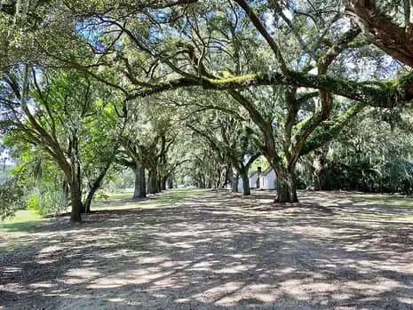
Photo: w_lemay, CC BY-SA 2.0, via Wikimedia Commons. Museum · James Island
McLeod Plantation Historic Site
Guided tours are included with admission and focus on Gullah Geechee history and the transition to freedom; pets and bicycles are not permitted.
Outdoors · Fee
- guided interpretive tours
- riverside pavilion
- oak allee
325 Country Club Dr, Charleston, SC 29412
Official site · Checked
Courts
Courts · James Island
Bayview Soccer Complex
This is the City of Charleston soccer complex on the Fort Johnson Road side of James Island.
Outdoors
- soccer fields
- drinking fountain
- picnic tables
- Restrooms
1045 Fort Johnson Road, Charleston, SC 29412
Official site · Checked
Courts · James Island
Maybank Tennis Center
The city tennis center offers annual memberships as well as lessons through its teaching pro.
Outdoors
- tennis
1880 Houghton Drive, Charleston, SC 29412
Official site · Checked
Courts · James Island
Outdoor Adventure Center (Palmetto Peaks Climbing, Marshside Disc Golf)
The 18-hole Marshside disc golf course is included with regular park admission; the climbing and zipline attractions are priced separately.
Outdoors · Fee
- outdoor climbing wall
- zipline and high ropes
- kids' zipline
- 18-hole disc golf course
- gear shop
871 Riverland Dr, Charleston, SC 29412
Official site · Checked
Nothing on this list matches every filter you picked. Clear one to see more.
Parks, beaches and places to go around Charleston →
Local facts on this page checked October 3, 2026.
See what your numbers actually support.
Live rates for your scenario, the whole sheet side by side, and every closing fee — before we talk.
Jeff Moran, NMLS #483943, licensed to originate in South Carolina through C2 Financial Corporation.